Tuesday, February 14, 2012

Setting up a GEOCACHE

Setting Co-ordinates.


Here the team members have located a spot to set up a geocache. They have decided to put a pencil sharpener into the container. There is also an EXCEL sheet in the container. To-day the waypoint will be entered in Latitude/Longitude format. These co-ordinates will be released at school later in the day. Whoever finds the cache will remove the sharpener, relace it with some other "treasure", sign and date the logbook (EXCEL sheet) and then republish the co-ordinates.

Sunday, February 12, 2012

First GEOCACHE

Last week we set up our first Geocache. We started with a very simple exercise. A team member hid a 10 cent coin under a recycling bin on the school grounds. This location was set as a waypoint and given a name. The rest of the team using the electronic compass on the device logged on the geocache icon and followed the directions. Another bonus associated with this exercise is the fact that the device records walking speed which creates more problem solving testing Speed, Time and Distance. As we get more familiar with geocaching we will enter more waypoints. Instead of naming the waypoints we will now enter latitude and longitude as location clues.

Monday, February 6, 2012

Report from The Summit

Reporting on a Trip to Ireland's Highest Peak.

On the 29th of January 2012 I was in a party of thirteen people which climbed the highest mountain peak in Ireland. This peak is called Corrán Tuathail. Master gave me the GPS (Global Positioning System). I tracked to the foot of the mountain. Before I trekked I entered Cronin's Yard as a waypoint. After we got to the foot of the mountain we started climbing. We had to climb rocks and cross waterfalls.Then we stopped for a break. I was the
youngest on the climb. The second leg was the hardest of them all because of the snow. When we got to the top there was another break. I saw a cross and the ruins of a house at the summit. The highest point is 1045 metres. We came down "The Devil's Ladder" which is very steep. When we got to the bottom we went to the cafe. Here I signed the visitors' book.
Overall it was a very good experience !
I would love to do it again sometime when the weather gets better !!!!!


Saturday, February 4, 2012

More of Corrán Tuathail.


Here is the active log approaching the summit.
We have established an Index No. and captured Time, Date, Altitude, Latitude and Longitude.

Problem Solving

Look at the 2 logs in this post.
At 09:06:24 the group has arrived at an altitude of 356 metres.
On this data capture work out how many more metres must be climbed to reach the summit.
Also calculate how much time it took to reach the summit.
Document changes in Latitude and Longitude between the 2 locations.


Local natural climbers


The log at the top.


Friday, February 3, 2012

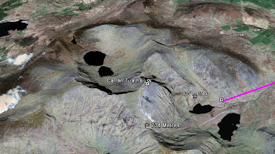
Corrán Tuathail the Highest Peak in Ireland.

One of our GPS team members climbed to the summit of Corrán Tuathail last Sunday morning 29th January 2012. This was a mighty task and experience. She travelled with her GPS tracking routes, entering waypoints and capturing as much raw data as possible. We publish her findings. She is at the moment writing a scientific report on her expedition and when it is ready we will post it.

This is a big post so keep scrolling.

Do not forget to click on image for a better view.

The other team members think she did a great job.


General Overview


Thursday, February 2, 2012

Where are we?

Here we are in relation to Dublin, London, Amsterdam and Brussels to mention just a few.

Nearest Geocache to Knockaclarig NS.

Here are some details on the nearest Geocache (Locate the Geocache icon on your GPS) to Knockaclarig NS.